
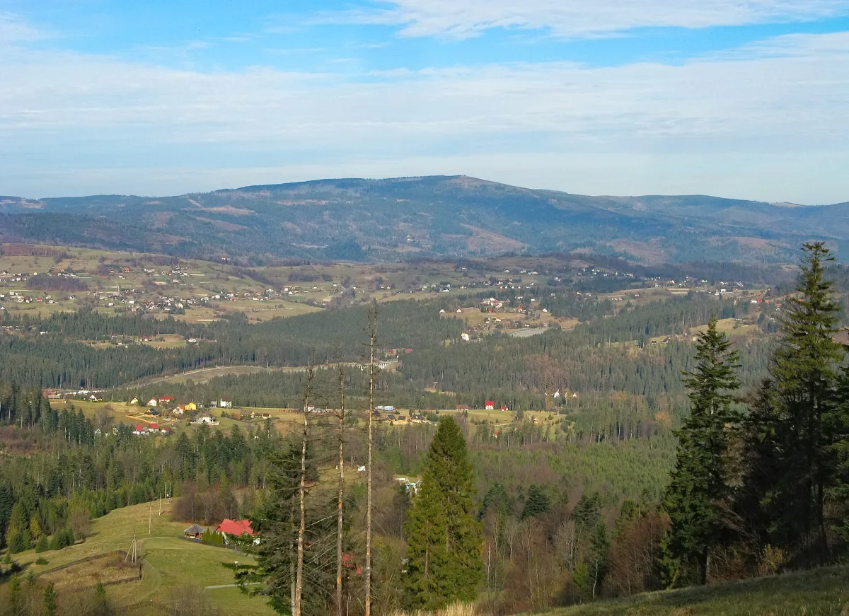
The mountain where Poland's longest river begins
Barania Góra is 1215 metres high and is the second highest peak of the Silesian Beskids after Skrzyczne. The figure of 1220 metres often appears in the literature, but it refers to a geodetic point on a concrete obelisk, located almost five metres above the ground. The summit lies on the border of Cieszyn County and Żywiec County, and the boundaries of Wisła and Kamesznica meet at the top. The Main Beskid Trail runs over the mountain, and the whole massif is part of the Silesian Beskids.
The question of where the Vistula really begins has no single answer, because it depends on what we take to be the beginning of the river. There are three different points of reference, and it is worth separating them before anyone sets off in search of a single spring.
Three streams, three answers
In the geographical sense the Vistula has two source streams: the Biała Wisełka and the Czarna Wisełka. Both rise on the western slopes of Barania Góra. The sources lie at 1107 metres above sea level in the case of the Czarna Wisełka and 1080 metres in the case of the Biała. This is where the discrepancies begin: according to other sources maps place its sources at 1148 metres, and that the whole source area lies at an average height of about 1150 metres. The sources do not settle which figure is correct.
The Czarna Wisełka is about 9 kilometres long. Its sources take the form of seepages, small watercourses with a flow of less than a litre per second, which trickle out of boggy patches and small pools on the marshy slopes below Wierch Wisełki. The Biała Wisełka measures about 7 kilometres and flows through a deep, narrow valley. In its middle section it forms rapids and waterfalls called the Rodło Cascades. Its name probably comes from the white water foaming over the rapids. The two streams meet in Lake Czerniańskie in Wisła Czarne, a reservoir created in 1973, built as a retention reservoir and a store of drinking water.
The stream flowing out of the lake is called the Wisełka. Only after it takes in the waters of the Malinka, below the bridge in Nowa Osada, is it called the Vistula. For this reason, in the hydrological sense, the Vistula begins where the Malinka joins the Wisełka. The Malinka is 8.1 kilometres long, and its sources lie at about 945 metres, on the western side of the ridge, between Malinowska Skała and Zielony Kopiec. It is regarded as the third source stream. In the area there is also the Malinowska Cave, open to visitors, below the summit of Malinów, but it has no connection with the beginning of the river itself.
The dispute over which stream is the more important was already under way in the 19th century. Wincenty Pol, who visited the sources of the Vistula in 1843, regarded the Czarna Wisełka as the main source stream. In a work of 1851 he wrote that it begins at eight strong springs on the mountain called Barani, below Czarny Wierch. The first documented trip to the summit of Barania Góra was the expedition of 14 August 1810 made by the future Duke of Pszczyna, Ludwig von Anhalt-Köthen-Pless.
Nature reserves that protect the beginning of the river
The source area and the summit are covered by the strict forest reserve Barania Góra. Its area is given in different ways: some sources say 386 hectares, and the reserve's record says 379.85 hectares. There is no need to settle this to understand that it is a large, compact block of forest from a height of about 840 metres up to the summit itself. Precipitation here is among the highest in the country, from 1100 to 1700 millimetres a year. The current reserve was created by an order of the Minister of Forestry on 5 November 1953, but earlier these forests had been protected by the Habsburgs of Cieszyn, who came here to hunt capercaillie.
The streams themselves have separate protection. The Wisła nature reserve was created in 1959, covers 17.61 hectares and includes the watercourses of the Biała and Czarna Wisełka, the source stretch of the Vistula down to the mouth of the Malinka, and the Malinka stream itself. The aim was to protect the native population of brown trout. According to the description of the reserve, the regulation of the streams, the dam in Wisła Czarne, and acidification and pollution of the water caused the trout to die out in the Czarna Wisełka, while in the Biała they survive thanks to restocking.
Przysłop: lodge, mountain hut and museum
The easiest access to this area is provided by the Przysłop clearing. In 1897 Archduke Frederick Habsburg built a wooden hunting lodge here, a base for capercaillie hunts. The record of the lodge describes it as a wooden manor house of 1897-1898, probably built to a design by Albin Teodor Prokop. After the First World War the building was devastated, and in 1925 the Upper Silesian branch of the Polish Tatra Society opened a mountain hut in it. In 1985 the lodge was moved to the centre of Wisła, where, as the Habsburg Hunting Lodge (Pałacyk Myśliwski Habsburgów), it is the seat of a PTTK branch.
Next to the clearing stands the PTTK mountain hut at Przysłop below Barania Góra. The height of the clearing is given differently by different sources: from 900 to 951 metres above sea level. The brick, three-storey hut building was put up in 1973-1979. In the wooden outbuilding of the former hut is the Museum of Mountain Tourism, that is, the Barania Góra Centre for the History of Mountain Tourism “U źródeł Wisły” (At the Sources of the Vistula). It was opened on 12 November 1994, and the idea was put forward in 1967 by Edward Moskała. From Przysłop to the summit it takes, according to the trail description, about an hour.
Trails fan out around the summit to Skrzyczne, Malinowska Skała, the Salmopol Pass and Wisła Czarne. At the top stands a steel observation tower of 1991, built on the initiative of the Beskid Guides' Circle in Katowice, and in good visibility it offers views of the Little Beskids, Babia Góra and the Tatras. Anyone who wants to see the beginning of the river, and not only the summit, should choose the valley of the Biała or Czarna Wisełka: an asphalt road from Wisła Czarne runs along the Czarna Wisełka, and in both valleys there is a nature trail.
A monument to the river in town
The beginning of the river is also commemorated by a monument in the town centre. In Wisła stands the Monument to the Sources of the Vistula (Pomnik Źródeł Wisły), designed by Konstanty Laszczka: a girl with flowers walking across a meadow beside a pool of fish, with streams running down a rock that refer to Barania Góra. It was unveiled in 1937 by President Ignacy Mościcki during the Mountain Festival (Święto Gór), which Wisła hosted that year. The sculpture was destroyed by the Germans during the Second World War, and the present monument is a replica of the original. The replica was unveiled in 2014.
Be the first! Add a comment.
You need to log in to add a comment.
Log in