
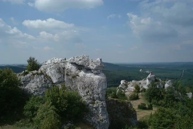
The limestone outcrops of Góra Zborów can be seen from provincial road no. 792 between Żarki and Kroczyce. It is one of the best-known climbing places in the Polish Jura, and at the same time a nature reserve containing the only cave in the northern part of the Kraków-Częstochowa Upland that is open to visitors. The hill itself is described on the page Góra Zborów.
The hill where witches gathered
The name Góra Zborów is linked to a legend: the local witches were supposed to gather here before flying off on broomsticks to the sabbath on Łysa Góra in the Holy Cross Mountains. This is a legend, not a historical finding, but it conveys the character of the place well. Rocks jut out at the top, and the treeless summit is a viewpoint.
Góra Zborów is regarded as the highest elevation of the former Częstochowa Voivodeship, and the sources differ on its height. Some give 467.5 m above sea level, others 462 m. At the summit stands Skała ze Słupem (the Rock with a Pillar), on which a concrete triangulation pillar was installed during the German occupation.
The hill belongs to the range of the Kroczyce Rocks, which stretches for more than 3 km (about 4 km according to another description). To the west of Kroczyce lies Kołoczek, the second of the hills covered by the reserve. Administratively the reserve is in the village of Kroczyce, although some descriptions, including our page, name the neighbouring Podlesice.
An inanimate nature reserve
The reserve was established by a ministerial order of 30 August 1957. It covers 45 ha and two hills, Góra Zborów and Kołoczek, densely covered with limestone outcrops up to 30 metres high. It lies within the Natura 2000 area Ostoja Kroczycka and in the Trail of the Eagles' Nests Landscape Park.
On the rocks grow xerothermic grasslands and rock vegetation, also the blue pink (goździk siny) and the clustered saxifrage (skalnica gronkowa), regarded as a glacial relict. Birds mentioned include the eagle owl, the rock thrush and the red-backed shrike. It is precisely because of the grasslands on the tops of the rocks that it is forbidden to climb onto them, as they are being restored there.
Rocks and climbers' shelters
Climbers have given the rocks their own names: Biała Baszta, Dwoista Baszta, Krucze Skały, Sfinks, Wielbłąd, Młynarze, Koguty and many others. There are more than twenty of them, and the walls are covered with a dense network of climbing routes. Climbing is allowed under certain rules, which should be checked in the reserve's regulations before the trip.
The rocks also contain many low caves and rock shelters. At the base of Biała Baszta opens the Schronisko pod Białą Basztą, with an entrance 2.5 m wide and a small chamber. It is a site to look at from outside, not a visitor route.
Jaskinia Głęboka: traces of the quarry and of spar
Jaskinia Głęboka lies at the foot of Krucze Skały and Dwoista Baszta, in the western part of the reserve. It is visited with a guide, and tickets are sold by the ticket office at the Centre of Natural and Cultural Heritage of the Jura by the car park next to the road from Podlesice to Kotowice.
The dimensions are given differently. According to the centre, the cave is 190 m long with a vertical range of 22.4 m, while other sources speak of 170 m in length and 12.5 m in depth. All the sources agree that even on hot days the temperature inside does not exceed 8 degrees Celsius.
The surroundings of the cave are the part of the reserve most altered by humans. During the Second World War the Germans opened a limestone quarry here, which cut through the cave and added openings to it. Originally it had two entrances, later four, and some of them were walled up in order to restore a stable microclimate. Spar, that is crystalline calcite, was also extracted here: before the war in the Leje Szpatowców, through which the cave is still entered today, and after the war in the Southern Chamber. Drill holes and broken lumps of calcite can still be seen.
The cave is a refuge for bats, which hibernate here in winter. The changeable temperature after the quarry cut through it had a harmful effect on the hibernating animals.
The Trail of the Eagles' Nests and the rocks beyond the forest
Next to the cave runs the red Trail of the Eagles' Nests, which leads from Góra Janowskiego through Morsko and Góra Zborów further to Bobolice, Mirów and Niegowa. From the upper parts of the rocks one can see the castle in Morsko and more distant strongholds, including Bobolice Castle and Mirów Castle. A nature trail and the green Rzędkowice Trail also lead through the reserve.
If you want to see more Jurassic outcrops and caves, in the municipality of Janów stand the ruins of Ostrężnik Castle with the Schronisko Większe, and in the forest near Zastudnie lies hidden the Schronisko z Dzikiem with the neighbouring rock Bezlik. These are forest sites without infrastructure, so they require a route to be planned in advance.
Be the first! Add a comment.
You need to log in to add a comment.
Log in